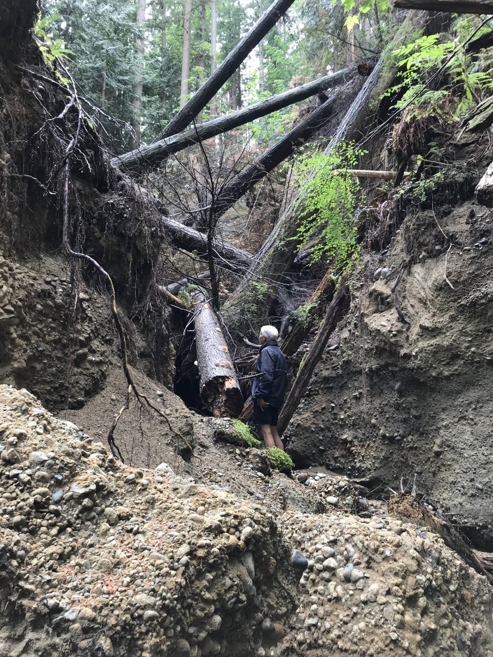
Concern and frustration are mounting for a group of Granthams Landing residents who say rising volumes of rainwater runoff could be putting Soames Creek, and their homes, at risk.
“It is a major problem in the making,” said Sarah Macdonald, a resident of Elphinstone Avenue whose property is metres from the creek. If the Ministry of Transportation and Infrastructure (MOTI) dealt with it, they could avert it, she told Coast Reporter. “Otherwise, five years down the road we’re going to be looking at a real disaster.”
Macdonald is among 40 residents in the West Howe Sound neighbourhood who last July signed a letter alerting MOTI and other officials to the accelerating erosion damaging roads, homes and habitats.
Erosion has been a longstanding issue in the picturesque neighbourhood, known for its expansive ocean views thanks to steeply sloped roads, but problems have mounted in the past year – the most glaring example being Soames Creek.
“It’s a Niagara falls of Granthams Landing,” explained Mark Hiltz, Sunshine Coast Regional District (SCRD) director for West Howe Sound, who worked with the group on the letter to MOTI.
During storms, rainwater gushes down a drainage ditch along an undeveloped section of Reed Road, and over a 10-metre cliff, inundating the creek. Over the past year, the excessive overland runoff has been carving a deepening crater. Trees half-a-metre thick have been heard toppling into the chasm.
Further complicating matters is that the Granthams Well, which supplies drinking water to residents in the area, is located at the bottom of Soames Creek. And edging the ravine is Granthams Hall, under renovation. The proposed site for the Church Road well field, a critical project that could supply drinking water to thousands on the Sunshine Coast, is also located near the creek.
The SCRD says the erosion does not pose a risk to the proposed well field.
Residents worry about the risk to their properties and the creek itself.
“We’re losing the forest,” said Mary Burns, a 17-year resident of Elphinstone Avenue whose property, like Macdonald’s, edges onto the undeveloped road allowance and expanding ravine. “Right now the trees are falling into the creek,” she said. “If the trees start falling this way … it’s worrying.”
The erosion has affected a trail system maintained by the SCRD that runs from Elphinstone Avenue through the forest to Shirley Macey Park. Parks staff have been forced to relocate a footbridge three times in the past year to circumvent the ravine, and orange caution tape and temporary fencing blocking off a portion of trail is expanding as the chasm widens. “[The fence] was 30 feet from my back property line, it’s now maybe 12,” Macdonald said. She also worries that trees could start falling onto her property.
Despite those concerns, the province has been slow to respond, says the group.
It took MOTI five months to reply to the letter with 40 signatories. When a response did come last November, operations manager Michael Braun assured the group the ministry is “taking this issue seriously,” and acknowledged the “need to conduct a more thorough drainage study.”
MOTI made similar comments to Coast Reporter, adding, “The ministry continues to work closely with the SCRD regarding the issue and addressing the residents’ concerns,” and that “safety is the ministry’s top priority, and ministry staff and maintenance contractors regularly monitor B.C.’s highways and roads in order to maintain safe passage for people.”
If a study does occur, it wouldn’t be the first.
A 2006 stormwater study highlighted the problem of upland development creating more runoff, and included the remedy of installing a culvert to divert the excess water more effectively, but that never happened. Neither did a 2011 MOTI “project wish list” item to install riprap to de-energize the water, at an estimated cost of $30,000.
So drainage and erosion issues persist, and the ravine continues to widen.
“We seem to have passed a threshold,” Hiltz told Coast Reporter. “You stand out there, you look into a chasm and go, that’s a problem. It scares people. It has reduced the access to the uplands through the trail. So the question is, who pays for it? And I think this is [what] it comes down to.”
Residents, meanwhile, are also concerned about the local infrastructure in the area.
SCRD infrastructure manager Remko Rosenboom assured Coast Reporter the proximity of the well field to the creek doesn’t pose a risk. “I don’t see how the development of the wells would in any way increase any risk of erosion in the area,” he said. He also told Coast Reporter the SCRD is “fully aware of the situation and we looked into the questions about what could be causing this and who is responsible for addressing it.” He said MOTI has indicated the issue is within their jurisdiction.
The upshot of the proximity to the proposed wells, however, is that if the project proceeds, the Granthams Well is expected to be decommissioned and new watermains installed on Elphinstone Avenue and Reed Road, which may lead to opportunities for improved roads and drainage.
MOTI told Coast Reporter they are “aware that the SCRD has some utility works planned for the area,” and “will continue to work with partners at the SCRD on future improvements in the Granthams Landing area.” SCRD interim CAO Mark Brown said, “This would be a great opportunity to discuss solutions with MOTI in conjunction with the SCRD project.”
Budget adoption in the spring will provide more clarity on whether the project will move forward, and at what pace. In the meantime, residents will keep waiting.
“I know there must be so many issues to deal with, but this is going to be expensive on so many fronts,” said Burns. “It can’t be patchwork. We’re ultimately paying for it, so we have a concern.”


