Sunshine Coast Regional District (SCRD) is asking the province to put a proper consultation process in place for renaming requests.
The move comes at the BC Geographical Names Office’s request for comments without allowances for a public consultation process on a shIshálh Nation proposal to change names for 10 geographical features in the shIshálh swiya.
“Frankly ridiculous” was Area E director Donna McMahon's reaction to the lack of consultation process.
In a Sept. 15 letter from the office, considered at the Sept. 22 Board meeting, the SCRD and 14 other area groups and organizations were asked to “redirect this request to the appropriate contact within your organization as needed.” Responses were requested before Dec. 18.
“Basically work is being downloaded on us. They [the Province] are not doing a proper public consultation. They apparently have no intention of doing it and if we want to consult the community then we are supposed to do it at our own expense…and this will continue as there are likely going to be more in the future,” McMahon stated.
The board supported McMahon’s motion to ask the province to put a proper consultation process in place for such requests, in addition to having staff report back on implications of the proposed name changes for the SCRD’s operations.
Area A director Leonard Lee said he was “disappointed with the process," and asked staff what conducting a regional district referral and consultation would entail.
Chief administrative officer Dean McKinley responded that work was not budgeted for or included in existing work plans. “But if so directed, I would imagine that we would find a way,” he stated.
Changes proposed
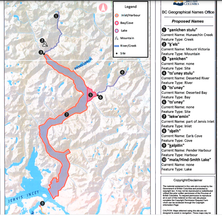
Here are the name proposals within the SCRD:
- kalpilin: The harbour along the northwest side of Sechelt Peninsula, between Sechelt and Powell River, currently known as Pender Harbour.
- skelh: Earls Cove, the cove at the north end of Sechelt Peninsula facing the north end of Agamemnon Channel.
- mala/Hind-Smith Lake: the lake within Tetrahedron Park east of Chapman Lake and northwest of Panther Peak.
The other seven name change requests involve features outside of the SCRD’s jurisdictional territory:
- enichen stulu: Hunaechin Creek
- enichen: The site located at the junction of Hunaechin Creek (enichen stulu) and Skwawka River.
- keIs: Mount Victoria – the mountain at the head of Queens Reach, Jervis Inlet (northeast of the community of Powell River)
- Iekw’emin: The northeast part of Jervis Inlet, made up of Prince of Whales Reach, Princess Royal Reach and Queens Reach.
- ts’unay stulu: Deserted River, the river that flows southwest into Deserted Bay (ts’unay) at the northeast end of Princess Royal Reach.
- ts’unay: Deserted Bay
Additional information on the locations and audio recordings of the pronunciation of the proposed names is available through the BC Geographical Names Web App.


