No timeline for shortlisting Highway 101 alternate routes between Gibsons and Halfmoon Bay is included in the recently released public and stakeholder engagements report on proposed options. The Ministry of Transportation and Infrastructure (MOTI) issued the report based on that check-in exercise completed in mid-2022.
According to the document, there will be a “multiple account evaluation” (MAE) on the options presented. Once that is complete, the report states “the Ministry, shíshálh Nation and Squamish Nation will recommend a preferred long-term solution…a decision on a preferred long-term routing for the corridor will follow”. As for when recommendations will be developed and made public, it states “timing to be confirmed”.
The ministry’s website outlines that those next steps, “will help refine the list of feasible options for further analysis and costing”. A background document available from the ministry explains that MAE is a tool designed to provide a balanced view to decision makers on “necessary compromises”. It allows comparisons of options within a given project like Highway 101 improvements as well as to other department projects. In addition, it allows for projects to be compared with the need to spend on other priorities in the province such as health, education and social services.
Local reaction
The executive summary of the 108-page report rejects the idea of a complete highway do-over, stating “there is no foreseeable need for a full, end-to-end bypass route”.
Coast Reporter reached out to Sunshine Coast Highway Society spokesperson Robin Merriott for his opinion on the report. His statement: “it’s an awful lot of words and pictures to say nothing”.
He expressed frustration with the amount of time it has taken to get to this point, which he said “is still basically nowhere” when it comes to making improvements to the Coast’s main transportation corridor.
Merriott was pleased to see the shíshálh Nation as partners with the province in the planning for the future of the highway and said that as always the society’s response to the ministry on the report would be copied to the Nation as well as others. In helping to draft that response, he said he would like to ask for a full explanation on how the statement in the report that “highway traffic volumes have grown approximately 20 per cent since 2017” was arrived at. He said he was unsure what that estimate is measuring. As a local driving the route on a daily basis, he said his observation is that the overall "busyness” of the highway has increased by much more than that over the past five years.
Transportation Choices Sunshine Coast (TraC) president Alun Woolliams, shared views from that group on the document. While glad to see active transportation improvements being recognized as "fundamental" in the report, his concern is that creating bypass routes "won't magically make our current highway any safer for cyclists or pedestrians".
According to a June 28 email, TraC supports highway adjustments that prioritize easily accessible bus stops, frequent transit service, a dedicated multi-use path for pedestrians and cyclists parallel to the existing highway, and a pedestrian and cycling-friendly ferry service connecting the Lower Mainland to the Sunshine Coast. Those features "align with the goals outlined in CleanBC's Roadmap to 2030 and promote modal shift, which is crucial for achieving a sustainable transportation system," Woolliams wrote.
Consultation summaries
The report summarizes input received on four highway segment areas as covered in last year’s engagement process. Those comments were gathered from stakeholders including local governments, other provincial departments and agencies, along with industry groups, as well as the general public’s participation in online events and via social media.
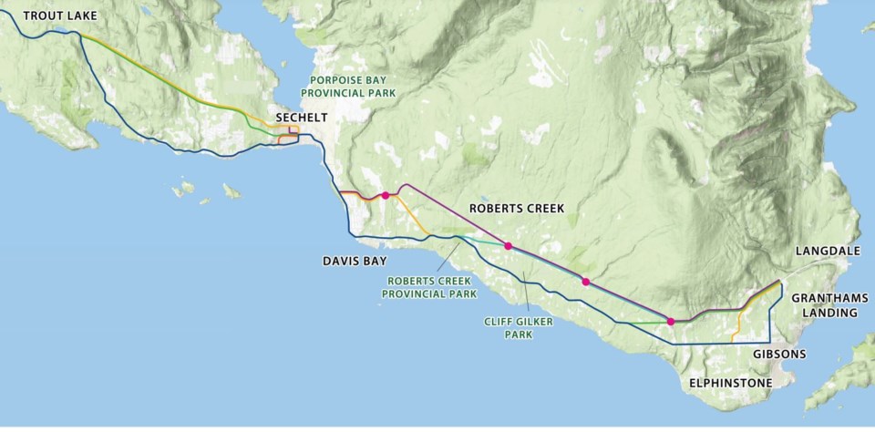
For the Gibsons area (Stewart to Largo Roads), the option presented for a full alternate route along the BC Hydro right-of-way was preferred by most respondents. Improving within the existing highway route ranked second, and alternatives involving Ranch or Payne Road were preferred by fewer respondents. Concerns related to the environment and potential residential impacts associated with building any alternate route were identified.
Input from the town included suggestions to improve local traffic with connections from North to Payne Road and from Gibsons Way and Reed Road. A focus on the safety of a variety of intersections, active transportation infrastructure improvements, the impacts of climate change and impacts on Gibsons’ aquifers was also requested.
Safety, impacts for residents and thoughts about active transportation were considerations across all options for the Davis Bay (Largo Road to Chelpi Ave.) segment. The full alternate route via Havies Road emerged as the most preferred route, with options via Park Avenue and Margaret Road receiving less support during the engagement process. Factors such as traffic flow, emergency routing across Chapman Creek, adding travel options and separating ferry and logging traffic away from local traffic were key considerations in discussion of alternate routes.
Within the core area of Sechelt (Chelpi to Shorncliffe Ave.), traffic flow and impact to residents were key considerations with five routing alternatives under review. The options of improving the existing route, re-routing portions via Wharf and Neptune or a Dolphin Street alternate all garnered similar levels of interest. Proposals involving Dolphin connecting via Trail Avenue and a link from Dolphin to Shorncliffe were ranked lower by those involved in the engagement process.
For the options as Highway 101 continues toward Trout Lake, the North Sechelt alternate route (Wharf and Neptune) ranked first, improvements within the existing corridor ranked second and the North Sechelt connector route (via Dolphin) was a distant third preference.
Those final three segments involve areas of the Sunshine Coast Regional District (SCRD) and the District of Sechelt. The report noted that Sechelt “declined to provide feedback on specific options in advance of public engagement” and requested its review comments be part of the “next phase” of study and technical analysis on highway re-routing.
The report showed that the SCRD had a lot to say when MOTI sought its input. It cited that local government supports development of alternate routes as highway closures have a significant impact for transit services, emergency responses and potential evacuation routes. Concerns about the safety of those using alternate transportation on Highway 101 were expressed along with the need for consideration of including alternatives to single occupancy motor vehicle traffic within re-routing plans. Comments about applying lenses related to regional planning, a Community Climate Action Plan, ocean level rise, storm water and drainage management, social equity to option analysis were raised. Also suggested was route alternates that could see highway through traffic separated from local traffic, including solid waste collection pick up route. The SCRD asked for further study into any route alignments that would impact “drinking water aquifers”.
As for what will come next, the MOTI website states it will continue “to ensure everyone is updated as the study progresses” but no schedule of future information releases is included.

